投稿

Key Messages for Hurricane Ian ハリケーン「イアン」最新情報
イメージ
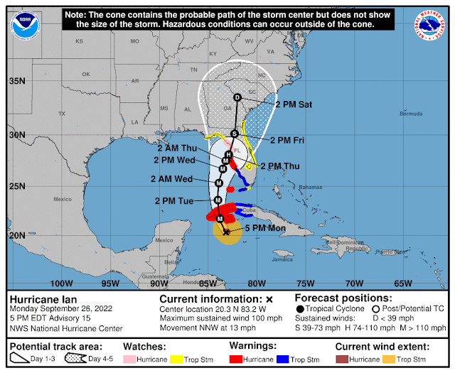
1. 命の危機に迫る高潮、ハリケーン級の暴風、鉄砲水、土砂崩れが火曜日にかけ、キューバ西部の一部で発生する可能性があります。ハリケーン「イアン」の中心がキューバ西部を横切って移動する際は、暴風による壊滅的な被害が発生する恐れがあります。生命と財産を守るため の行動を早めに行うようにしてください  2. 高潮警報が発令されているフロリダ西海岸の広い範囲で命の危機に迫る高潮の危険があります。 フォートマイヤーズからタンパベイ地域までのリスクが最も高く、これらの地域にお住まいの方は、地元自治体のアドバイスに留意してください 3. フロリダ州中西部のハリケーン警報が発表されている地域では、水曜日の朝からハリケーン級の暴風が予想されます(火曜日遅くまでは熱帯低気圧級です)  4. フロリダ全体で大雨が増加します。火曜日にフロリダキーと南部、水曜日と木曜日にフロリダ中部と北部に広がり、鉄砲水、都市部での洪水、川の氾濫を引き起こす可能性があります。 フロリダ州中部では川の氾濫が長期化する恐れもあるでしょう。 1. Life-threatening storm surge, hurricane-force winds, flash floods and possible mudslides are expected in portions of western Cuba beginning this evening and continuing into Tuesday. Devastating wind damage is possible where the core of lan moves across western Cuba. Efforts to protect life and property should be rushed to completion.  2. There is the danger of life-threatening storm surge along much of the Florida west coast where a storm surge warning has been issued, with the highest risk from Fort Myers to the Tampa Bay ...

TROPICAL STORM IAN(熱帯低気圧イアン)

イメージ
  9月25日(日曜日)午前11時(米東部夏時間)、日本時間26日(月曜日)午前0時 1.熱帯低気圧イアンにより、大雨、鉄砲水、標高が高いところでは土砂崩れが発生する恐れがあります。特にジャマイカとキューバは危険です。またフロリダキーズ諸島とフロリダ半島全体で、週の半ばまでは鉄砲水と都市型洪水が発生する可能性があります。 さらに今週後半には、フロリダ州北部とアメリカ南東部の一部を横切る河川で、洪水が発生する恐れがあるでしょう。  2. キューバ西部の一部地域では、月曜日の遅い時間帯から命に関わるほど危険な高潮とハリケーン級の暴風が予想され、現在、ハリケーン警報が発令されています。早めに命と財産を守る行動を終えるようにしてください。 3. 熱帯低気圧イーアンは、週の半ばにメキシコ湾東部で大きなハリケーンに発達すると予想さ れていますが、長期的な進路と強度の予測に関しては通常よりも不確実性が高い状況です。ただイーアンの実際の進路と強度に関係なく、週の半ばまでにはフロリダ西海岸とフロリダ・ パンハンドルでは、危険な高潮、ハリケーン級の暴風、および大雨のリスクがあります。フロリダ住民は確実にハリケーン対策を実施し、地元当局からの情報に従い、最新の予報に留意する必要があります。 1.Ian is expected to produce heavy rainfall, flash flooding, and possible mudslides in areas of higher terrain, particularly over Jamaica and Cuba. Flash and urban flooding is possible across the Florida Keys and Florida peninsula through mid week. Additional flooding on rivers across northern Florida and parts of the southeast U.S. cannot be ruled out later this week.  2. Life-threatening storm surge and hurricane-force winds are expected...

26日までに台風17号が発生

イメージ
マリアナ諸島付近にある熱帯低気圧が26日までに台風17号になる見込みです。 熱帯低気圧は現在、マリアナ諸島にあって、北北西にゆっくり進んでいます。中心気圧は1004hPa、最大瞬間風速は23メートルです。26日には小笠原諸島の父島に南海上に達し、台風に発達する予想です。台風はその後、進路を次第に東に変え、30日には日本のはるか東で温帯低気圧に変わるでしょう。 小笠原諸島では台風の接近により、26日から27日にかけては暴風、高波、大雨に警戒が必要です。 The tropical depression near the Mariana Islands is expected to become Typhoon No. 17 by the 26th. The tropical depression is now over the Mariana Islands and is slowly moving north-northwest. The central pressure is 1004hPa and the maximum instantaneous wind speed is 23m/s. It is expected to reach the south of Chichijima Island in the Ogasawara Islands on the 26th and develop into a typhoon. The typhoon will then change course gradually to the east, turning into an extratropical depression far east of Japan on the 30th. A typhoon is approaching the Ogasawara Islands, and from the 26th to the 27th it is necessary to be on alert for storms, high waves, and heavy rain.

非常に強い台風16号 フィリピンを直撃

イメージ
非常に強い勢力の台風16号はまもなくフィリピンのルソン島を直撃する見込みです。 25日午後3時現在、台風はフィリピンのルソン島の東にあって、時速20キロで西に進んでいます。中心気圧は940hPa、最大瞬間風速は70メートルです。 台風は今後、勢力を維持しながらルソン島に上陸し、26日午後に南シナ海に抜ける予想です。その後は勢力を徐々に弱めながら西に進み、29日にタイに上陸して熱帯低気圧に変わるでしょう。 A very strong Typhoon No. 16 is expected to hit Luzon Island in the Philippines soon. As of 3:00 pm on the 25th, the typhoon is east of Luzon Island and is moving west at 20 kilometers per hour. The central pressure is 940hPa and the maximum instantaneous wind speed is 70m/s. The typhoon is expected to make landfall on Luzon Island while maintaining its intensity, and advance to the South China Sea on the afternoon of the 26th. After that, it is expected to move west while gradually weakening its strength, and make landfall in Thailand on the 29th and turn into a tropical cyclone.

来週、台風3号が沖縄接近か?

イメージ
  4月にフィリピン近海で台風2号が発生して以降、新たな台風が発生しない状況が続いていますが、最新のアメリカ環境予測センター(NCEP)の全球数値予報(GFS)の計算では、来週後半に台風が発生する可能性が出てきました。予想では、6月29日水曜日にフィリピンの東で熱帯低気圧が発生し、7月1日金曜日に沖縄付近を通過。その後、上海方面に進む見通しです。熱帯低気圧は発達次第で台風3号になるかもしれません。 ただ、ヨーロッパ中期予報センター(ECMWF)の計算では、熱帯低気圧にならないほどの低圧部の予想となっていて、熱帯低気圧が発生するかどうかはまだはっきりと言えない状況です。 Since typhoon No. 2 occurred in the sea near the Philippines in April, no new typhoon has continued, but the latest Global Forecast Prediction (GFS) calculations of National Centers for Environmental Prediction (NCEP) show a possibility that a new typhoon will occur in the second half of next week. It is expected that a tropical cyclone will occur in the east of the Philippines on Wednesday, June 29, and will pass near Okinawa on Friday, July 1. After that, it is expected to proceed toward Shanghai. Tropical cyclones may become typhoon No. 3 depending on their development. However, according to the calculation by the European Center for Medium-Range Predictors (ECMWF), it is predicted that the low p...

台風2号発生 1号は小笠原諸島へ

イメージ
台風1号は現在、発達しながらマリアナ諸島を北西に進んでいます。 あすには強い勢力に発達し、13日水曜日には非常に強い勢力になる見込みです。予報通りに進んだ場合、15日金曜日に小笠原諸島に接近する可能性があります。今のところ本州への接近はなさそうです。 一方、フィリピンの東海上にあった熱帯低気圧が台風2号になりました。現在、台風に伴う発達した雨雲が、ミンダナオ島北東部のカラガ地方などに断続的に流れ込んでいて、フィリピンの気象機関であるフィリピン大気地球物理天文局(PAGASA)は、大雨や強風、沿岸部での高波に注意を呼びかけています。 なお、4月での台風2個発生は2014年以来8年ぶりのことになります。 Typhoon No. 1 is currently developing and moving northwest through the Mariana Islands. It will develop into a strong force tomorrow and is expected to become a very strong force on Wednesday, 13th. If it goes according to the forecast, it may approach the Ogasawara Islands on Friday the 15th. It seems that there is no approach to Honshu so far. On the other hand, a tropical cyclone over the eastern sea of the Philippines became typhoon No. 2. Currently, developed rain clouds associated with the typhoon are intermittently affecting the Karaga region in the northeastern part of Mindanao, and the Philippine meteorological agency, the Philippine Atmospheric and Geophysical Astronomical Age...

台風1号発生 次第に北上

イメージ
4月8日(金)午前9時に台風1号が発生しました。 現在はカロリン諸島を時速15キロで北西に進んでいます。中心気圧は996hPa。中心付近の最大風速は20m/ sです。 台風は10日(日)にはフィリピンの東に達し、強い勢力に発達する見込みです。11日(月)には非常に強い勢力になり北に進路を変え、その後次第に東寄りに進む予想です。 台風の影響で来週、太平洋側の海上は次第にうねりを伴うでしょう。 Typhoon No. 1 occurred at 9:00 am on April 8 (Friday). It is currently traveling northwest on the Caroline Islands at a speed of 15 km / h. The central pressure is 996 hPa. The maximum wind speed near the center is 20 m / s. The typhoon is expected to reach the east of the Philippines on Sunday, 10th, and develop into a strong force. It is expected that it will become a very strong force on the 11th (Monday), change its course to the north, and then gradually move to the east. Due to the typhoon, the sea on the Pacific side will gradually swell next week.