投稿

2023の投稿を表示しています

Typhoon LAN Set to Impact Tokai, Kinki, and Shikoku During Obon Period

イメージ
As of 9:00 AM on Friday the 11th, Typhoon LAN, an extremely strong typhoon, is slowly moving northward over the sea approximately 90 kilometers southeast of Chichi-jima Island. The central pressure is 940 hectopascals, the maximum sustained wind speed near the center is 45 meters per second, and the maximum gust speed is 65 meters per second. Within a radius of 130 kilometers from the center, there is an area of storm-force winds with speeds exceeding 25 meters per second. The typhoon is expected to continue moving northward while intensifying. There is a possibility that by next Tuesday the 15th, it could directly hit the Tokai region with strong force. As of now, the forecast cone indicating the area where the center of the typhoon has a 70% probability of entering is relatively wide, as the typhoon's future track has not been precisely determined. Therefore, it is important to be aware that it could come quite close not only to the Tokai region but also to the Shikoku and Kinki

No Prospect of Hurricane Dora Direct Hit on Hawaii

イメージ
Hurricane Dora Advisory Number 22 NWS National Hurricane Center Miami FL EP052023 1100 AM HST Sat Aug 05 2023  At 1100 AM HST (2100 UTC), the center of Hurricane Dora was located near latitude 13.3 North, longitude 134.8 West. Dora is moving toward the west near 18 mph (30 km/h), and this motion is expected to continue with some increase in forward speed during the next few days.  Maximum sustained winds have increased to near 130 mph (215 km/h) with higher gusts. Dora is a category 4 hurricane on the Saffir-Simpson Hurricane Wind Scale. Some additional strengthening is possible this afternoon and tonight. Dora is then expected to weaken beginning Sunday and continuing through Monday.  Dora remains a small hurricane. Hurricane-force winds extend outward up to 25 miles (35 km) from the center and tropical-storm-force winds extend outward up to 45 miles (75 km).

Typhoon KHANUN Expected to Make Landfall in Kyushu

イメージ
  KHANUN  is currently passing near Tokunoshima, Kagoshima Prefecture. As of 6:00 AM, the central pressure is 970 hPa, and the maximum wind speed near the center is 30 m/s, with maximum gusts of 40 m/s. The typhoon is slowly moving eastward. The Amami region and parts of Okinawa Main Island are experiencing strong winds of 25 m/s or more. The typhoon is expected to make a right-angle turn to the north on Monday, the 7th, and head towards mainland Kyushu. If it follows the center of the forecasted path, it is projected to make landfall on the Satsuma Peninsula in Kagoshima Prefecture on Wednesday, the 9th. Afterward, it is likely to pass through northern Kyushu, including Kumamoto and Fukuoka Prefectures, and head towards the Tsushima Strait. The typhoon's slow movement suggests that the impacts, such as heavy rainfall, strong winds, and high waves, may persist for an extended period. [Announcement from the Japan Meteorological Agency on August 6, 2023, 05:21 AM] In the Southwest I

KHANUN: Direct Hit on Amami, Headed for Kyushu

イメージ
KHANUN is moving eastward over the East China Sea. As of 5:00 AM, the central pressure is 970 hPa, with maximum sustained winds near the center at 30 m/s and maximum gusts of 45 m/s. The southern parts of the Amami Islands and the Okinawa Main Island region are currently experiencing strong winds exceeding 25 m/s. Although the typhoon’s intensity has slightly weakened, it remains powerful, and there is a possibility of it intensifying again over the Pacific after directly impacting the Amami Islands on Sunday the 6th. Following that, it is expected to change its course to the north and make landfall in either Miyagi or Kagoshima Prefecture on Wednesday the 9th, traversing Kyushu. Due to the slow movement of the typhoon, the impacts such as heavy rain, strong winds, and high waves may persist for an extended period. [Announcement by the Japan Meteorological Agency on August 5, 2023, at 5:33 AM] In the Okinawa and Amami regions, please exercise extreme caution against strong winds, high

Typhoon KHANUN Forms, Set to Make Direct Hit on Okinawa Next Week

イメージ
  At 3 a.m. on the 28th, the tropical depression over the eastern waters of the Philippines developed into Typhoon KHANUN. As of 9 p.m., the central atmospheric pressure is 1000 hPa, with maximum sustained winds near the center at 18 m/s and maximum gusts reaching 25 m/s. It is moving northwestward at a speed of 15 km/h. If it follows the track connecting the center of the forecasted circle, KHANUN is predicted to make a direct hit on Okinawa Main Island on Monday night, the 31st. Subsequently, it will move northwestward over the East China Sea and approach the vicinity of Shanghai on Wednesday, the 2nd. As  KHANUN  approaches, Okinawa and Amami are likely to experience rough seas, stormy weather, heavy rain, and high waves. There may also be potential impacts on air and sea transportation. As of 9 a.m. on the 28th, there is a maximum of 70% probability that Okinawa and the southern regions of Amami will enter the area of destructive winds with wind speeds of 25 m/s or higher. The prob

New Tropical Depression Forms, Expected to Become Typhoon No. 6

イメージ
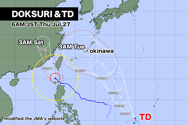
While a large and extremely powerful Typhoon DOKSURI is moving northward towards the Chinese mainland, a tropical depression has formed over the eastern waters of the Philippines. The tropical depression is expected to develop into Typhoon No. 6 within the next 24 hours and continue its northward trajectory. Typhoon No. 6 is anticipated to approach Okinawa Main Island on Tuesday, August 1st, with a strong intensity. There is a possibility of Okinawa and Amami being significantly affected by destructive winds, high waves, heavy rainfall, and other associated impacts.

Next Typhoon Poses Direct Hit Threat to Okinawa

イメージ
Typhoon DOKSURI, a large and extremely powerful typhoon, is moving northwestward, engulfing parts of Luzon Island in the Philippines with winds exceeding 25 m/s in the destructive wind zone. It is expected to maintain its intensity and continue moving northward. If it follows the track connecting the center of the forecasted circle, it is anticipated to make landfall near Zhangzhou City, Fujian Province, China, on Friday, the 28th. On the other hand, the next tropical depression is expected to form over the eastern waters of the Philippines, with the possibility of developing into a typhoon. As of Tuesday, the 25th, the European Centre for Medium-Range Weather Forecasts (ECMWF) has forecasted that the next typhoon will directly hit Okinawa Main Island on Wednesday, August 2nd. The central atmospheric pressure is expected to drop to below 980 hPa. The National Oceanic and Atmospheric Administration (NOAA) in the United States, however, predicts a faster progression, indicating that the

Next Typhoon Predicted Following DOKSURI

イメージ
As of 3 p.m. on Sunday, Typhoon DOKSURI is currently located over the eastern waters of the Philippines and moving in a northwestward direction at a speed of 10 km/h. The central atmospheric pressure is 985 hPa, with maximum sustained winds near the center at 30 m/s and maximum gusts reaching 40 m/s. Destructive winds with speeds of 25 m/s or higher are associated with the typhoon. The typhoon is expected to gradually intensify and continue moving in a northwestward direction. By tomorrow, Monday, it is likely to reach a strong intensity, and by the following day, Tuesday, it may become a very powerful typhoon. The peak strength is anticipated to be on Tuesday, with the central atmospheric pressure possibly dropping to 925 hPa. If the typhoon follows the forecasted track's center, it is predicted to pass through Taiwan early on Thursday, the 27th, and make landfall near Putian City in Fujian Province, China, on Friday, the 28th. The probability of Ishigaki-jima and Iriomote-jima en

Typhoon Set to Directly Hit Taiwan

イメージ
As of 6 p.m. on Saturday, the 22nd, Typhoon DOKSURI is moving westward at a speed of 10 km/h off the Eastern Coast of the Philippines. The central atmospheric pressure is 998 hPa, with maximum sustained winds near the center at 20 m/s and maximum gusts reaching 30 m/s. On the eastern side of the center, strong winds of 15 m/s or more extend up to 440 km, and on the western side, they extend up to 330 km. The typhoon is expected to gradually intensify and move in a northwesterly direction. By Monday, the 24th, it will reach a strong intensity, and by Tuesday, the 25th, it will become a very powerful typhoon. The peak intensity is expected to be on Wednesday, the 26th, with the central atmospheric pressure possibly dropping to 925 hPa. If the typhoon follows the forecasted track's center, it will make a direct hit on Taiwan from Wednesday night, the 26th, until Thursday morning, the 27th. It will come closest to the Yaeyama Islands, including Ishigaki-jima and Iriomote-jima, on Wedne

Typhoon No. 5 has formed and is heading towards the Senkaku Islands.

イメージ
  At 9 a.m. today, the tropical depression located to the east of the Philippines developed into Typhoon No. 5. The central atmospheric pressure is 1002 hPa, with maximum sustained winds near the center at 18 m/s and maximum gusts reaching 25 m/s. Within 440 km to the northeast and 330 km to the southwest of the center, strong winds of 15 m/s or more are blowing, and the typhoon is moving at a speed of 15 km/h towards the north-northwest. As it moves over areas with warm sea temperatures, it is expected to strengthen and continue its northward trajectory. By Monday, the 24th, it is anticipated to reach a strong intensity, and by Wednesday, the 26th, it may become a very powerful typhoon. If the forecast remains accurate, on Wednesday, the 26th, there is a risk of experiencing winds of 25 m/s or more on the Sakishima Islands of Okinawa, such as Miyako-jima and Ishigaki-jima. As of now, the probability of Miyako-jima and Ishigaki-jima entering the area of destructive winds on Wednesday,

台風5号がまもなく発生

イメージ
フィリピンの東海上にある熱帯低気圧が、24時間以内に台風5号になる見込み。 21日金曜日午前0時現在、熱帯低気圧の中心気圧は1006hPa、中心付近の最大風速は15m/ s、最大瞬間風速は23m/sで、時速約15km/ hで北に進んでいる。 熱帯低気圧が予報円の中心を進んだ場合、23日日曜日にフィリピンの東で強い勢力になり、その後、25日火曜日には沖縄の南で非常に強い勢力に発達する。 25日火曜日21時の暴風警戒域に沖縄の宮古島や石垣島などが入ってきた。 来週後半は沖縄に接近する可能性があり、警報級の大雨、暴風、うねりを伴った高波による被害が出る恐れがある。 現在、フィリピンから種子島、屋久島付近までの海域では、水温が約30度と高く、台風が発達するエネルギーである水蒸気が十分に供給される環境にある。このため台風は非常に強い勢力を維持、またはさらに発達して沖縄に接近するかもしれない。 ただ来週は太平洋高気圧の勢力が強まるため、台風が本州方面に接近する可能性は低い。 アメリカ海洋大気局の予想では、26日水曜日に沖縄の八重山諸島を通過してそのまま東シナ海を北上、中国大陸へ進む。 中期ヨーロッパ予報センターの予報では、27日木曜日午前に台湾を直撃してその後、中国大陸へ進む見込みだ。   A tropical depression located over the eastern sea of the Philippines is expected to become Typhoon 5 within the next 24 hours. As of 12:00 AM on Friday, the 21st, the central pressure of the tropical depression is 1006 hPa, with maximum sustained winds near the center at 15 m/s and maximum gusts at 23 m/s. It is moving north at a speed of about 15 km/h. If the tropical depression follows the forecast track, it is projected to intensify into a stro

ハリケーン「カルヴィン」ハワイ島を直撃か

イメージ
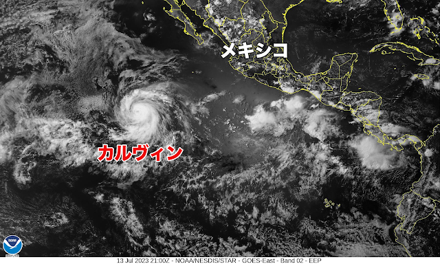
ハリケーン「カルヴィン」は火曜日の夜から水曜日にかけてハワイ島(ビッグアイランド)に最も接近、ハワイ島では大雨、高波、局地的な強い風が予想されている。 水曜日の日中から夜にかけては、ハワイ諸島の南側を西に進み、周辺へ影響を与えつつ、勢力を弱めていく。 雨に関して:  火曜日の夜から木曜日にかけて、ハワイ島の風下地域では合計約100〜180ミリ、ほかの地域では約25〜100ミリの降水量が予想されている。この雨により、局地的な洪水や土砂崩れが発生する可能性がある。 波に関して:  カルヴィンによる海上のうねりは、数日後にハワイ諸島全域に到達する見込み。このうねりで、非常に危険な高波が予想される。地元気象機関の情報の確認を。 18日午前0時現在、 風速20.6 m/s 最大風速22.3 m/s 12時間後 18日午前9時 風速18.5 m/s 最大風速20.1 m/s 24時間後 18日午後9時 風速18.5 m/s 最大風速20.1 m/s 36時間後 19日午前9時 風速18.5 m/s 最大風速20.1 m/s 48時間後 19日午後9時 風速16.2 m/s 最大風速17.8 m/s 60時間後 20日午前9時 風速13.9 m/s 最大風速15.6 m/s 72時間後 20日午後9時 風速11.1 m/s 最大風速13.4 m/s 96時間後 21日午後9時に消滅 NWS Central Pacific Hurricane Center Honolulu HI EP032023 500 AM HST Mon Jul 17 2023 Calvin is forecast to pass very close to the Big Island Tuesday night and Wednesday, bringing a period of heavy rain, high surf and locally strong winds. Calvin is expected to weaken as it moves westward to the south of the other Hawaiian Islands Wednesday and Wednesday night, bringing the potential for some peripheral

台風4号 広東省を直撃

イメージ
台風4号がまもまく中国広東省の湛江市(たんこうし)に上陸する見込み。 現在、雷州市(らいしゅうし)もあわせて風速25m/s以上の暴風域に入っており、強い風を伴い大雨になっている模様。台風はあす火曜日は、トンキン湾、華南を西に進んで、あさって水曜日はベトナムに達し熱帯低気圧に変わる。  午後9時現在、台風の中心気圧は970hPa、中心付近の最大風速は30m/s、最大瞬間風速は45m/ s。時速20キロで西北西に進んでいる。 台风4号预计将登陆中国广东省湛江市。目前,雷州市也进入了风速超过25米/秒的暴风区,伴随着大雨。预计台风将于明天星期二穿过东京湾,向西南方向前进,并于后天星期三到达越南,转变为热带低压。 截至晚上9点,台风的中心气压为970百帕,中心附近的最大持续风速为30米/秒,最大阵风速度为45米/秒。它以每小时20公里的速度向西北西方向移动。 Dự kiến siêu bão số 4 sẽ đổ bộ vào thành phố Trấn Giang, tỉnh Quảng Đông, Trung Quốc. Hiện tại, cả thành phố Trấn Giang và thành phố Lô Châu đều nằm trong vùng gió mạnh với tốc độ trên 25m/s, đi kèm theo mưa lớn. Dự kiến siêu bão sẽ di chuyển về phía tây qua Vịnh Bắc Bộ và miền Nam Trung Quốc vào ngày mai, thứ ba, và đến Việt Nam vào ngày kia, thứ tư, nơi nó dự kiến sẽ suy yếu thành áp thấp nhiệt đới. Hiện tại, áp suất tâm của siêu bão là 970hPa, tốc độ gió tối đa gần trung tâm là 30m/s, tốc độ gió giật cực đại là 45m/s. Siêu bão di chuyển với vận tốc 20km/h về phía tây bắc. Typhoon No. 4 is expected to make lan

台風4号 ベトナム直撃の恐れ

イメージ
きのう土曜日に南シナ海で発生した台風4号は、やや発達しながら西寄りに進んでいる。 午前9時現在、中心気圧は980hPa、中心付近の最大風速は25m/s、最大瞬間風速は35m/s。時速10km/hの比較的ゆっくりしたスピードで西北西に進んでいる。 台風はこのあとも西に進む予想で、予報円の中心を進んだ場合、18日火曜日にトンキン湾、19日水曜日にベトナムに進み、熱帯低気圧に変わる見込み。 日本への直接の影響はないが、ベトナムでは18日火曜日から19日水曜日にかけて、大雨、暴風、高波に警戒が必要だ。 Typhoon No. 4, which formed in the South China Sea yesterday, is moving slightly westward while gradually intensifying. As of 9:00 AM, the central pressure is 980 hPa, the maximum sustained wind speed near the center is 25 m/s, and the maximum gust speed is 35 m/s. It is moving at a relatively slow speed of 10 km/h towards the west-northwest. The typhoon is expected to continue moving westward, and if it follows the center of the forecasted track, it is projected to reach the Gulf of Tonkin on Tuesday the 18th and Vietnam on Wednesday the 19th, eventually transitioning into a tropical depression. There will be no direct impact on Japan; however, in Vietnam, caution is necessary for heavy rain, strong winds, and high waves from Tuesday the 1

ハリケーン「カルビン」は来週初めにハワイ諸島へ

イメージ
2023年7月14日金曜日 午前11時ハワイ標準時(世界標準時14日21時) アメリカ国立ハリケーンセンターによると、ハリケーン「カルビン」はこのあと太平洋中部を進み、来週初めにハワイ諸島に接近する予想。進路、強度、構造に不確定要素があるため、影響の正確な位置や大きさを特定することは現時点では難しいが、ハワイの在住者および関係者は最新の予報情報を注視する必要がある。 ハリケーン「カルビン」の中心は北緯13.8度、西経124.6度付近にあり、時速16マイル(26キロメートル)で西北西に移動中。このあと数日は同じ動きを続ける見込み。 最大風速は毎時125マイル(毎時205キロ)近くまで強まっており、さらに強い突風も吹いている。 現在カテゴリー3の勢力のカルビンは、明日から週の初めにかけて勢力が弱まると予想される。 ハリケーン級の暴風は中心から外側に35マイル(55キロ)まで、熱帯低気圧級の強風は中心から外側に115マイル(185キロ)まで広がっている。中心気圧は955ヘクトパスカル(28.20インチ)。 ◾️陸地への影響・危険性 カルビンによる海上のうねりは来週初めにハワイ諸島に到達する予想で、危険な高波と激しい潮流の状況が予想される。地元の気象事務所からの情報の確認を。 NWS National Hurricane Center Miami FL  At 1100 AM HST (2100 UTC), Calvin is forecast to move across the central Pacific Ocean and approach the Hawaiian Islands early next week. It is too early to determine the exact location and magnitude of potential impacts given uncertainties in the track, intensity, and structure of Calvin as it approaches the islands. Interests in Hawaii should closely monitor the latest forecast updates. The center of Hurricane C

秋田県では大雨による災害の危険度高まる

イメージ
秋田県では活発化した梅雨前線の影響で大気の状態が非常に不安定になっている。 県内には発達した積乱雲が次々と流れ込み、一部で大雨になっていて、14日正午の降り始めからの総雨量は男鹿で130ミリを超え、秋田市でも100ミリを超えている。16日にかけて雨は断続的に降り続く見込みで、一部では非常に激しい雨が降るおそれがある。  午前9時現在、土砂災害警戒情報が 秋田市秋田、秋田市河辺雄和、能代市、男鹿市、北秋田市、上小阿仁村、藤里町、三種町、八峰町、五城目町、八郎潟町 に出されている。 【2023年07月15日05時22分 仙台管区気象台発表】 東北北部では、前線や暖かく湿った空気の影響により、大雨となっている所があります。16日にかけて、大雨による土砂災害、低い土地の浸水、河川の増水や氾濫に厳重に警戒してください。 また、東北日本海側では、15日昼前から夕方にかけて暴風に警戒してください。  【気象状況】  梅雨前線が朝鮮半島から東北北部を通り、日本の東へのびています。前線は、16日にかけて東北北部付近に停滞し、前線に向かって暖かく湿った空気が流れ込むため、活動が活発な状態が続くでしょう。また、15日は、北日本では気圧の傾きが大きくなる見込みです。 【予想と防災事項】 <雨の予想>  東北北部では、警報級の大雨となっている所がある。15日朝から昼過ぎにかけては、非常に激しい雨の降る所がある見込み。 15日に予想される1時間降水量は、いずれも多い所で、 東北北部 50ミリ 東北南部 30ミリ 16日に予想される1時間降水量は、いずれも多い所で、 東北北部 30ミリ 東北南部 30ミリ 15日6時から16日6時までに予想される24時間降水量は、いずれも多い所で、 東北北部 200ミリ 東北南部 120ミリ その後、16日6時から17日6時までに予想される24時間降水量は、いずれも多い所で、 東北北部 50から100ミリ 東北南部 50から100ミリ <風と波の予想>  東北日本海側では、15日は南西の風が強く、しける見込み。  15日に予想される最大風速(最大瞬間風速) 東北日本海側 海上 18メートル(30メートル) 東北日本海側 陸上 18メートル(30メートル) 15日に予想される波の高さ  東北日本海側 5メートル  <防災事項> 東北北部では、16日にかけて、警報基

台風4号が発生する見込み

イメージ
南シナ海にある熱帯低気圧が24時間以内に台風4号になる見込み。 14日午後9時現在、中心気圧は998ヘクトパスカル、中心付近の最大風速は15メートル(30ノット)、最大瞬間風速は23メートル(45ノット)。時速20キロ(10ノット)で南西に進んでいる。 台風が予報円の中心を進むと、18日火曜日にトンキン湾を通過し、18日夜遅くから19日水曜日かけてベトナムに上陸。その後、熱帯低気圧に変わる。 A tropical depression located in the South China Sea is expected to become Typhoon 4 within the next 24 hours. As of 9:00 PM on the 14th, the central pressure is 998 hPa, with maximum sustained winds near the center at 15 meters per second (30 kt) and maximum gusts at 23 meters per second (45 kt). It is moving southwestward at a speed of 20 kilometers per hour (10 kt). If the typhoon follows the forecasted track, it will pass through the Gulf of Tonkin on Tuesday the 18th and make landfall in Vietnam from late evening on the 18th through Wednesday the 19th. Afterward, it will transition into a tropical depression.

ハリケーン「カルヴィン」が発生

イメージ
現地時間の木曜日未明から明け方にかけて熱帯低気圧・カルヴィンはハリケーンへと格上げされた。 ハワイ標準時の木曜日午前11時(日本時間の金曜日午前6時)、ハリケーン・カルヴィンの中心は北緯12.8度、西経118.7度付近にあり、時速14マイル(22キロ)で西に向かって移動。数日間は西から西北西方向へ進むと予想されている。 最大風速は時速80マイル(130キロ)で、さらに強い突風が吹いている。あと1日ほど勢力が若干強まる見込みだが、海水温が低いエリアに移動する週末からは徐々に弱まる。 ハリケーン級の暴風は、中心から外側に25マイル(35キロメートル)まで、熱帯低気圧級の強風は中心から外側に80マイル(130キロメートル)まで広がっており、中心気圧は990ヘクトパスカル(29.24インチ)と推定される。 現在のところ陸地に影響を及ぼす危険性はない。 At 1100 AM HST (2100 UTC), the center of Hurricane Calvin was located near latitude 12.8 North, longitude 118.7 West. Calvin is moving toward the west near 14 mph (22 km/h), and a west to west-northwestward motion is expected to continue during the next few days. Maximum sustained winds are near 80 mph (130 km/h) with higher gusts. Some additional strengthening is forecast during the next day or so. Gradual weakening is forecast to begin by the weekend, as Calvin begins to move over cooler water. Hurricane-force winds extend outward up to 25 miles (35 km) from the center and tropical-storm-force winds extend o

あすにもハリケーン「カルビン」が発生

イメージ
  現地時間午前3時(世界標準時午前9時)現在、熱帯低気圧カルビンの中心は北緯12.4度、西経110.6度にあって、時速16マイル(26キロ)で西に進んでいる。今後数日はおおむねそのまま西に進む予想。 最大風速は、時速45マイル(75キロ)まで強まっており、さらに強い突風を伴っている。カルビンはこのあとさらに勢力を強め、あす木曜日にはハリケーンになる見込み。 暴風域は、中心から半径45マイル(75キロ)まで広がっている。中心気圧は1004ヘクトパスカル(29.65インチ)。 At 300 AM MDT (0900 UTC), the center of Tropical Storm Calvin was located near latitude 12.4 North, longitude 110.6 West. Calvin is moving toward the west near 16 mph (26 km/h), and a general westward motion is expected during the next several days. Maximum sustained winds have increased to near 45 mph (75 km/h) with higher gusts. Additional strengthening is forecast during the next couple of days, and Calvin is forecast to become a hurricane on Thursday. Tropical-storm-force winds extend outward up to 45 miles (75 km) from the center. The estimated minimum central pressure is 1004 mb (29.65 inches).

九州南部で大雨警戒続く

イメージ
九州南部では土砂災害に警戒が必要な状態が続いています。 鹿児島県では降り始めからの雨量が200ミリを超えているところがあり、現在、鹿児島市、いちき串木野市。日置市に土砂災害警戒情報が出されています。 【2023年07月04日05時20分 鹿児島地方気象台発表】 九州南部では、土砂災害に厳重に警戒してください。4日午前中にかけて、線状降水帯が発生する可能性があります。  九州南部から日本の南にのびる梅雨前線に向かって暖かく湿った空気が流れ込み大気の状態が非常に不安定となっています。梅雨前線は4日夜にかけて次第に不明瞭となる見込みです。  このため、九州南部では、4日夕方にかけて局地的に雷を伴った非常に激しい雨や激しい雨が降り大雨となるおそれがあります。また、5日は梅雨前線の活動が予想より活発になった場合は警報級の大雨となる可能性があります。5日にかけて局地的に積乱雲が発達し、落雷や竜巻などの激しい突風が発生するおそれもあります。 <雨の実況>  降り始め(2日22時)から4日5時までの降水量(アメダスによる速報値)  鹿児島県(奄美地方除く)    薩摩川内市八重山 223.0ミリ <雨の予想> 4日に予想される1時間降水量は、多い所で、  鹿児島県(奄美地方を除く) 70ミリ 5日に予想される1時間降水量は、多い所で、  鹿児島県(奄美地方を除く) 40ミリ 4日6時から5日6時までに予想される24時間降水量は、多い所で、  鹿児島県(奄美地方を除く) 250ミリ その後、5日6時から6日6時までに予想される24時間降水量は、多い所で、  鹿児島県(奄美地方を除く) 100から150ミリ 線状降水帯が発生した場合は、局地的にさらに雨量が増えるおそれがあります。 <防災事項>  厳重警戒:土砂災害  警戒事項:低い土地の浸水、河川の増水や氾濫  注意事項:落雷、竜巻などの激しい突風  発達した積乱雲の近づく兆しがある場合には、建物内に移動するなど、安全確保に努めてください。 In southern Kyushu, caution against sediment disasters is still necessary. In Kagoshima Prefecture, there are areas where the cumulative rainfall sin