投稿

Typhoon KHANUN Forms, Set to Make Direct Hit on Okinawa Next Week

イメージ
  At 3 a.m. on the 28th, the tropical depression over the eastern waters of the Philippines developed into Typhoon KHANUN. As of 9 p.m., the central atmospheric pressure is 1000 hPa, with maximum sustained winds near the center at 18 m/s and maximum gusts reaching 25 m/s. It is moving northwestward at a speed of 15 km/h. If it follows the track connecting the center of the forecasted circle, KHANUN is predicted to make a direct hit on Okinawa Main Island on Monday night, the 31st. Subsequently, it will move northwestward over the East China Sea and approach the vicinity of Shanghai on Wednesday, the 2nd. As  KHANUN  approaches, Okinawa and Amami are likely to experience rough seas, stormy weather, heavy rain, and high waves. There may also be potential impacts on air and sea transportation. As of 9 a.m. on the 28th, there is a maximum of 70% probability that Okinawa and the southern regions of Amami will enter the area of destructive winds with wind speeds of 25 m/s ...
New Tropical Depression Forms, Expected to Become Typhoon No. 6

イメージ
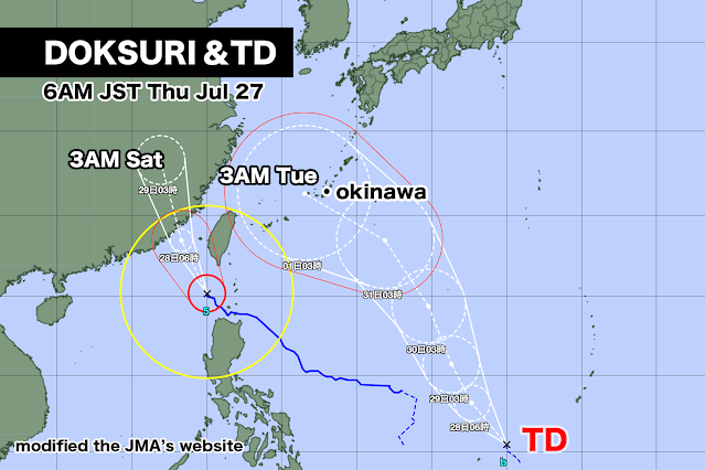
While a large and extremely powerful Typhoon DOKSURI is moving northward towards the Chinese mainland, a tropical depression has formed over the eastern waters of the Philippines. The tropical depression is expected to develop into Typhoon No. 6 within the next 24 hours and continue its northward trajectory. Typhoon No. 6 is anticipated to approach Okinawa Main Island on Tuesday, August 1st, with a strong intensity. There is a possibility of Okinawa and Amami being significantly affected by destructive winds, high waves, heavy rainfall, and other associated impacts.

Next Typhoon Poses Direct Hit Threat to Okinawa

イメージ
Typhoon DOKSURI, a large and extremely powerful typhoon, is moving northwestward, engulfing parts of Luzon Island in the Philippines with winds exceeding 25 m/s in the destructive wind zone. It is expected to maintain its intensity and continue moving northward. If it follows the track connecting the center of the forecasted circle, it is anticipated to make landfall near Zhangzhou City, Fujian Province, China, on Friday, the 28th. On the other hand, the next tropical depression is expected to form over the eastern waters of the Philippines, with the possibility of developing into a typhoon. As of Tuesday, the 25th, the European Centre for Medium-Range Weather Forecasts (ECMWF) has forecasted that the next typhoon will directly hit Okinawa Main Island on Wednesday, August 2nd. The central atmospheric pressure is expected to drop to below 980 hPa. The National Oceanic and Atmospheric Administration (NOAA) in the United States, however, predicts a faster progression, indicating that the ...

Next Typhoon Predicted Following DOKSURI

イメージ
As of 3 p.m. on Sunday, Typhoon DOKSURI is currently located over the eastern waters of the Philippines and moving in a northwestward direction at a speed of 10 km/h. The central atmospheric pressure is 985 hPa, with maximum sustained winds near the center at 30 m/s and maximum gusts reaching 40 m/s. Destructive winds with speeds of 25 m/s or higher are associated with the typhoon. The typhoon is expected to gradually intensify and continue moving in a northwestward direction. By tomorrow, Monday, it is likely to reach a strong intensity, and by the following day, Tuesday, it may become a very powerful typhoon. The peak strength is anticipated to be on Tuesday, with the central atmospheric pressure possibly dropping to 925 hPa. If the typhoon follows the forecasted track's center, it is predicted to pass through Taiwan early on Thursday, the 27th, and make landfall near Putian City in Fujian Province, China, on Friday, the 28th. The probability of Ishigaki-jima and Iriomote-jima en...

Typhoon Set to Directly Hit Taiwan

イメージ
As of 6 p.m. on Saturday, the 22nd, Typhoon DOKSURI is moving westward at a speed of 10 km/h off the Eastern Coast of the Philippines. The central atmospheric pressure is 998 hPa, with maximum sustained winds near the center at 20 m/s and maximum gusts reaching 30 m/s. On the eastern side of the center, strong winds of 15 m/s or more extend up to 440 km, and on the western side, they extend up to 330 km. The typhoon is expected to gradually intensify and move in a northwesterly direction. By Monday, the 24th, it will reach a strong intensity, and by Tuesday, the 25th, it will become a very powerful typhoon. The peak intensity is expected to be on Wednesday, the 26th, with the central atmospheric pressure possibly dropping to 925 hPa. If the typhoon follows the forecasted track's center, it will make a direct hit on Taiwan from Wednesday night, the 26th, until Thursday morning, the 27th. It will come closest to the Yaeyama Islands, including Ishigaki-jima and Iriomote-jima, on Wedne...

Typhoon No. 5 has formed and is heading towards the Senkaku Islands.

イメージ
  At 9 a.m. today, the tropical depression located to the east of the Philippines developed into Typhoon No. 5. The central atmospheric pressure is 1002 hPa, with maximum sustained winds near the center at 18 m/s and maximum gusts reaching 25 m/s. Within 440 km to the northeast and 330 km to the southwest of the center, strong winds of 15 m/s or more are blowing, and the typhoon is moving at a speed of 15 km/h towards the north-northwest. As it moves over areas with warm sea temperatures, it is expected to strengthen and continue its northward trajectory. By Monday, the 24th, it is anticipated to reach a strong intensity, and by Wednesday, the 26th, it may become a very powerful typhoon. If the forecast remains accurate, on Wednesday, the 26th, there is a risk of experiencing winds of 25 m/s or more on the Sakishima Islands of Okinawa, such as Miyako-jima and Ishigaki-jima. As of now, the probability of Miyako-jima and Ishigaki-jima entering the area of destructive winds on Wednesd...

台風5号がまもなく発生

イメージ
フィリピンの東海上にある熱帯低気圧が、24時間以内に台風5号になる見込み。 21日金曜日午前0時現在、熱帯低気圧の中心気圧は1006hPa、中心付近の最大風速は15m/ s、最大瞬間風速は23m/sで、時速約15km/ hで北に進んでいる。 熱帯低気圧が予報円の中心を進んだ場合、23日日曜日にフィリピンの東で強い勢力になり、その後、25日火曜日には沖縄の南で非常に強い勢力に発達する。 25日火曜日21時の暴風警戒域に沖縄の宮古島や石垣島などが入ってきた。 来週後半は沖縄に接近する可能性があり、警報級の大雨、暴風、うねりを伴った高波による被害が出る恐れがある。 現在、フィリピンから種子島、屋久島付近までの海域では、水温が約30度と高く、台風が発達するエネルギーである水蒸気が十分に供給される環境にある。このため台風は非常に強い勢力を維持、またはさらに発達して沖縄に接近するかもしれない。 ただ来週は太平洋高気圧の勢力が強まるため、台風が本州方面に接近する可能性は低い。 アメリカ海洋大気局の予想では、26日水曜日に沖縄の八重山諸島を通過してそのまま東シナ海を北上、中国大陸へ進む。 中期ヨーロッパ予報センターの予報では、27日木曜日午前に台湾を直撃してその後、中国大陸へ進む見込みだ。   A tropical depression located over the eastern sea of the Philippines is expected to become Typhoon 5 within the next 24 hours. As of 12:00 AM on Friday, the 21st, the central pressure of the tropical depression is 1006 hPa, with maximum sustained winds near the center at 15 m/s and maximum gusts at 23 m/s. It is moving north at a speed of about 15 km/h. If the tropical depression follows the forecast track, it is projected to intensify into a ...